Sunday, February 28, 2010

Warmer weather moving in!

6hr precip map for Noon Monday 03/08/10 (Map from NWS as of 03/01/10)

Pretty much all good news in this post. The chance of snow I posted about on Friday looks to miss us to the North and warmer temperatures will finally set in here in Topeka. The average temperature this time of year is 49 degrees, but the last time we have seen temperatures that high was 10 days ago on February 18, when we reached 51 degrees. So when will we hit 50 again you ask? Well were still a few days away from that. Temperatures this work week will range from the upper 30's to mid 40's, but we might finally reach 50 degrees by Friday or Saturday. Now to the two storm systems I talked about on Friday. The first system that was expected to move in this coming Friday looks to miss us to the North. This means southern winds and warmer temperatures for us. If we do receive precipitation it will be rain. I think our better chance of precipitation will come next Monday, but once again temperatures will be warm enough to keep this an all rain event.

Friday, February 26, 2010

More snow next weekend?


6hr Precipitation map for Noon on Friday, March 5 (Map as of 02/26/10)

The GFS forecast model is showing a good chance of precipitation for next Friday, March 5th and again on Monday, March 8th. The storm on Friday could produce more snowfall for the Topeka area so its definately worth watching. If we do receive all snow it could be up to 5-6 inches, but if I had to take a guess right now I think eastern and southern winds will keep us just warm enough to miss the big snow fall totals. On Monday I think were mostly looking at rain but again snow is not out of the question, so we could see another inch or two on Monday. This storm system is still 7-10 days away so a lot can change between now and then but for now it looks like next weekend could be pretty active for our area.

6hr Precipitation map for 6am Monday, March 8 (Map as of 02/26/10)

Tuesday, February 23, 2010

Temperatures to Remain Below Average

Temperatures will struggle to warm up and will remain well below average for the rest of February. The average high temperature between February 23-28 is 48 degrees and the average low is 26 degrees, but I don't see us reaching those numbers this week. Expected highs the next 5-days will be in the mid 20's to mid 30's, with lows falling into single digits to low 20's. Hopefully we will see the 40's again next week and melt some of this snow away.

Precipitation wise, we look to stay dry for the rest of the week. There is a slight chance of snow late Thursday night and Friday morning, but right now it looks like the heavier precipitation will miss us to the South. Another slight chance of precipitation will come Sunday night and Monday morning.

Sunday, February 21, 2010

Snow coming to an end

(Map shows 6hr snow amounts through 9pm Sunday)


Light snow continues here in Shawnee County. I measured 6 inches of snow in Silver Lake. I expect light snow to end by this evening. A trace up to an inch is possible before the snow is finished around 6:00pm tonight. Looks like we should stay dry the next few days but temperatures will be well below average. Highs will be in the upper 20's to low 30's with lows in the mid teens.
(Precipitation map for 6pm Sunday)


Saturday, February 20, 2010

Storm #2 Update


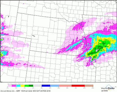
Snow Amounts Through 6am Monday (Map as of 11:00am 02/20/10)

As of this morning this winter storm still looks like it will bring significant snowfall totals to NE Kansas. Currently in the area we have light snow showers north of Manhattan and south of I-70 affecting the cities of Emporia, Baldwin City, and farther east into Olathe. Most of NE Kansas can expect an occasional light snow shower between now and 6pm. I don't expect major accumulations with this band of snow. A trace to 1 inch of snow can be expected for most of NE Kansas with slightly higher amounts closer to the Kansas/Nebraska border.
Type of Precipitation for 3am Sunday morning (Map as of 11:00am 02/20/10)
Purple=snow Blue=Freezing Rain Green=Rain

As the map above shows we will experience a mix of precipitation tonight and Sunday morning. The rain/snow line will start around the I-70 and I-35 area. Anything from snow, freezing rain, to sleet is possible in that area. I do think by Sunday around noon we should switch over to all snow as the temperature decreases falling into the low 20's by Monday morning. On the map below the 5400 line is the purple line on the map. It's usually a good indicator of where the rain/snow line is. It looks to be south and east of Topeka by noon on Sunday.

As for total snow amounts, I'm still going with 4-8 inches here in Shawnee County. Heavier amounts can be expected West of Topeka and also North and NE of Topeka. Areas that receive mostly snow could see amounts as high as 10-12 inches by late Sunday.


6hr Precipitation map for Noon on Sunday (Map as of 11:00am 02/20/10)

Friday, February 19, 2010

Storm #2

Snow Amounts Through 6am Monday (Map as of 9:00pm Friday)

It's starting to look like we have another very difficult storm to predict for this weekend. It's still 24 hours away so a lot can change between now and then so check back tomorrow around noon for another update. By then I should have a better idea of snow amounts for the Topeka area. This is a strong storm and areas that receive all snow could see up to 10 inches of snow. Right now for Topeka I'm going with 4-8 inches.


6hr precipitation map for 6pm Sunday Night (As of 9:00pm Friday)


Precipitation should start to form between 6pm and midnight on Saturday. The 5400 thickness line which is usually a good indicator of the rain/snow line appears to be setting up right on the I-70 and I-35 area for most of Saturday and Sunday morning. I think by Sunday between 3:00pm and 6:00pm the rain/snow line will shift farther east and south which will leave Topeka with all snow till about midnight Monday morning when the precipitation will come to an end. Before it switches to all snow we will see a winter mix. Anything from rain, freezing rain, to snow is possible and could switch back and forth a couple times. Temperatures will be in the low 30's on Saturday and Sunday morning. Starting Sunday afternoon temperatures will begin to fall into the low 20's by Monday morning. I will check the maps again tomorrow morning and will post another update by noon.

Storm #1

Snow Accum for Friday (Map as of 1:00pm 02-19-10)


It took a long time before I was ready to post Friday's forecast, but for storm #1 I'm going to go with a mostly rain event. It looks like the rain/snow line will be north of I-70 and close to the Kansas/Nebraska line. Precipitation will start forming around midnight on Thursday and should end by 6PM on Friday. The best chance of snow will be after noon on Friday, but I think its possible many areas around the I-70 area and especially south will only see rain. If you click on the map above it will show the heaviest snows (3-6 inches) along the KS/NEB border and the Missouri/Iowa border with amounts decreasing the farther south you go. Here in the Topeka area, I expect a trace to about an inch, but like I said wouldn't be surprised at all if we just see rain with temps around 35F. Another storm is poised to move in on Saturday night so it's now time to work on that forecast.

Tuesday, February 16, 2010

Snow Possible This Weekend

Map is for Friday at 6:00am (As of 11:00pm 02/16/10)


It looks like meteorologist will be busy the next couple days tracking 2 storms that could affect NE KS on Friday and again on Sunday. There is a good chance of precipitation on Friday. Depending on where the storm tracks it could mean a couple inches of snow for us or a mix of snow/rain. Then again late Saturday night and Sunday another system rolls in that could give us another chance of snow. It's a couple days away so a lot can still change.